by WorldCrosser Admin | Oct 30, 2015 | Roads, Routes, Virginia
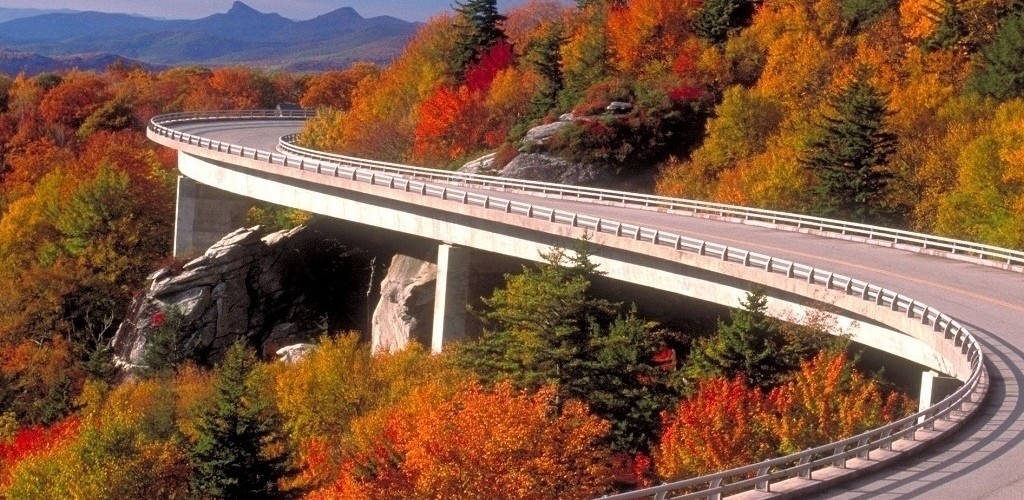
The Blue Ridge Parkways has been coined by some as “America’s Favorite Drive”.
Your can ride the Parkway from Shenandoah National Park in Virginia down to the Great Smoky Mountains in North Carolina. You will experience some great roads, some great views, some great towns, and of course great people. There are so many great towns to see that you would probably want a week or two to ride this great road.
[mapsmarker layer=”1″]
[mapsmarker marker=”5″][mapsmarker marker=”6″]
Here is a list of some great places you can stop on your ride: (these are taken from http://www.blueridgeparkway.org/ which is great resource for planning your ride.
- Biltmore – Asheville, NC +
- Chimney Rock at Chimney Rock State Park – Chimney Rock, NC +
- Great Smoky Mountains Railroad – Bryson City, NC +
- The Natural Bridge – Natural Bridge, VA +
- Staunton Tourism – Staunton, VA +
- The Altapass Orchard – Spruce Pine, NC
- Appalachian Caverns – Blountville, TN
- Barter Theatre – Abingdon, VA
- Blue Ridge Institute & Museum – Ferrum, VA
- The Blowing Rock – Blowing Rock, NC
- Blue Ridge Farm Museum – Ferrum, VA
- Bristol Caverns – Bristol, TN
- Booker T. Washington National Monument – Hardy, VA
- Christ in the Smokies – Gatlinburg, TN
- Cliffside Lake – Highlands, NC
- Cradle of Forestry Historic Site – Pisgah Forest, NC
- Dinosaur Land – White Post, VA
- Elijah Mountain Gem Mine – Hendersonville, NC
- Emerald Village – Spruce Pine, NC
- Flat Rock Playhouse – Flat Rock, NC
- Folk Art Center – Asheville, NC
- Gem Mountain Gemstone Mine – Spruce Pine, NC
- Grand Caverns – Grottoes, VA
- Grandfather Mountain – Linville, NC
- Linville Caverns – Marion, NC
- Lost Sea – Sweetwater, TN
- Luray Caverns – Luray, VA
- Museum of the Confederacy – Appomattox, VA
- Mystery Hill – Blowing Rock, NC
- Natural Bridge Zoological Park – Natural Bridge, VA
- The North Carolina Arboretum – Asheville, NC
- Ober Gatlinburg All Seasons Resort – Gatlinburg, TN
- Oconaluftee Indian Village – Cherokee, NC
- Old Salem – Winston-Salem, NC
- Pisgah Forest Gem Mine – Pisgah Forest, NC
- Ripley’s Aquarium of the Smokies – Gatlinburg, TN
- Roanoke Valley – Roanoke, VA
- Santa’s Land – Cherokee, NC
- Shenandoah Caverns – Shenandoah Caverns, VA
- Skyline Caverns – Front Royal, VA
- The Crooked Road – Virginia’s Heritage Music Trail – Abingdon, VA
- Tuckaleechee Caverns – Townsend, TN
- Tweetsie Railroad – Blowing Rock, NC
- Unto These Hills Outdoor Drama – Cherokee, NC
- Virginia Safari Park – Natural Bridge, VA
- Western North Carolina Nature Center – Asheville, NC
- WNC Farmer’s Market – Asheville, NC
Here is mobile app to help you experience the Blue Ridge Parkway on your Adventure Motorcycle.
Click here for info on mobile app.
by WorldCrosser Admin | Aug 31, 2015 | Canada, Dual Sport, Explore, Roads, Routes
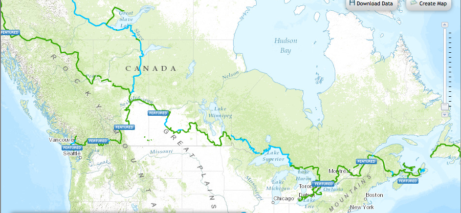
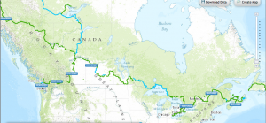
The Trans-Canada Trail is an awesome route that touches 3, that’s right 3 oceans! It is perfect for Adventure bikes as well as other recreational 4×4 overland vehicles. It is a network of trails, but starts in St. Johns, Newfoundland and ends in via a ferry ride to North Sydney, Nova Scotia. The Trans-Canada Trail claims to be the World’s longest recreational trail system, but is still in progress but when complete it will connect the Atlantic to the Pacific to the Arctic oceans!
Trans-Canada Recreation Trail is great for Adventure WorldCrosser Motorcycle Riders!
It is broken down into a few sections as it traverses the great country of Canada. When complete it will have shelter and fresh water along the trail system. It is a combined effort of over 400 community trails and has been funded by the Canadian government.
One doesn’t have to do the entire route in one trip, if they do not have the time and resources, but a leg of the trail can satisfy your Adventure craving and provide you a taste and experience of Canada. Remember you may want to sharpen up on your French as some Canadian towns you will be going through and stopping in may not speak English.
Read more about the sections, some stories of travelers and the trail itself at– http://tctrail.ca/
More Adventure motorcycle and dual sport centric is the TCAT – Trans-Canada Adventure Trail.
by WorldCrosser Admin | Aug 31, 2015 | Destinations, Explore, Other Adventures, Roads, Routes
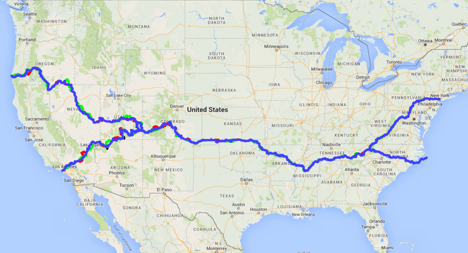
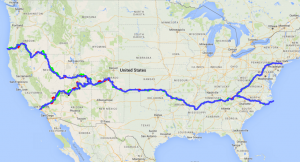
The Trans-America Trail, or TAT for short, is a American dual sport dream ADV ride across the US of A! It is a mix of dirt roads, farm roads, back roads, trails, and forest roads that go from southeast Tennessee and ends in southwest Oregon. And just like the TCAT, Trans-Canada Highway or many other long routes it can be broken down into sections or parts for shorter expeditions. As many of us don’t have a month or so to explore all that is offered on the TAT trail.
TAT or Trans-America Trail – An Adventure Motorcycle Ride Across the back roads and trails of the USA!
The TAT was originally mapped out by Sam Correro and he runs the website – http://www.transamtrail.com/ where you can get maps/gps files of the Trans-America Trail. Now Sam Correro, is respected as the father of the TAT trail, but many other passionate Adventure riders have extended the TAT and have improved the trail system even further by offering routes for different class adventure bikes. See ADV bike classes. And have also mapped out a complete coast to coast route as Sam’s route didn’t quite reach the east coast. So it is safe to say the TAT is a living growing trail system that many are now involved in making an amazing trans American route.
If you are interested in riding the TAT, another site that offers the maps and gps files for the TAT is gpsKEvin, see here. There is some controversy as to the ethics of gpsKevin’s offering these routes, many if not all gps files, after Sam has done so much of the leg work. gpsKevin’s initial take was “open-source” view where the trail and gps route is free to ride, but many feel it is a slight to the father of the TAT– now I believe the gps files are no longer free but he is charging for a MicroSD card for your GPS which obviously include his tracks. There is some concern that gpsKevin’s route may take riders across private land, where the land owner’s are not happy about the trespassing.
Another source for TAT route is TATtracks which takes Kevin’s route, but rerouted around all the private property, blocked roads, and closed gas stations. and best of all it’s free.
I’ll let you do your own due diligence and decide your own viewpoint on this one, but it is safe to say riding across America on an adventure bike will give you a taste of America from a real roots level.
And also check out the Big Dog who has rode many parts of the TAT and has a lot of great stuff on his site. http://www.bigdogadventures.com/
So get out there and Ride the TAT and explore the true America the ultimate way– on a motorcycle!
WorldCrosser has uniquely USA themed Trans-America Trail (TAT) stickers in stock.
Show off with a cool USA themed TAT sticker today.
as well as TAT vinyl decals too . . .

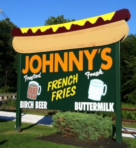
by WorldCrosser Admin | Aug 22, 2015 | Destinations, Food, New Jersey, Roads
make sure stop at hot dog johnny’s
motorcycle lunch spot nj route 46